Business routes of Interstate 40
Interstate 40 Business (I-40 BL) may refer to several business routes of the Interstate Highway System that connects Interstate 40 with the central business district of various cities bypassed by I-40.
Interstate 40 features 11 different sections of business loops in American Truck Simulator. They are located in Arizona, New Mexico, Texas, and Oklahoma, respectively in the cities of Flagstaff, Holbrook, Gallup, Tucumcari, and Clinton, as well as in the scenery towns of Seligman, Santa Rosa, Glenrio, Adrian, Shamrock, and Sallisaw.
Arizona
Seligman
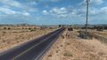
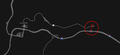
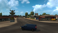
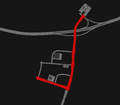
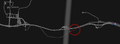
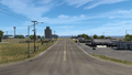
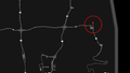
State Business Route 40 (1) (SR 40B (1)) is a business loop in Seligman in northwestern Arizona. The route begins at exit 121 of I-40 and heads north towards the town. It crosses over SR 66 and turns to the south until reaching its eastern terminus with SR 66 and the Historic US 66 in the town.
In real-life, SR 40B (1) continues east through the town, branches off of the historic portion of US 66 and heads south to exit 123 of I-40.
Junction list
| mi | km | Destinations | Facilities | Notes |
|---|---|---|---|---|
| 0 | 0 | Western terminus; I-40 exit 121 | ||
| 9 | 14 | Eastern terminus in-game; SR 40B (1) eastbound is inaccessible; SR 66 eastbound is inaccessible |
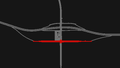
Gallery
View
Map


Flagstaff
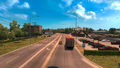
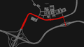
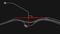
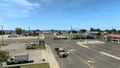
State Business Route 40 (4) (SR 40B (4)) is a business route in Flagstaff in northern Arizona. It begins at the junction with I-17 and 40, southwest of the city, and traces to the north for a few miles, and then it turns to the east, entering Flagstaff; soon afterwards, US 180 follows a concurrency with SR 40B. The route runs through the city for a mile before intersecting with US 89, and turns to the south until reaching its eastern terminus at exit 201 of I-40.
Junction list
| mi | km | Destinations | Facilities | Notes |
|---|---|---|---|---|
| 0 | 0 | Western terminus | ||
| I-40 exit 195 | ||||
| 3 | 5 | Western terminus of US 180 concurrency | ||
| 3 | 5 | Minor road | ||
| 3 | 6 | Leroux Street | ||
| 4 | 7 | TOTSO; southern terminus of US 89 | ||
| 6 | 10 | Eastern terminus; eastern terminus of US 180 concurrency; I-40 exit 201 |
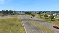
Gallery
View
Map


Holbrook
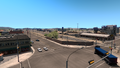
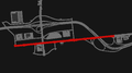
State Business Route 40 (8) (SR 40B (8)) is a business loop in Holbrook in eastern Arizona. The route begins at a minor road, at the Wigwam Motel, and traces to the east, following Hopi Drive. At its junction with US 180 and SR 77, the route turns to the north and follows a concurrency with US 180 and SR 77, which all follow Navajo Boulevard until reaching its eastern terminus at exit 286 of I-40.
In real-life, the western terminus is at exit 285 of I-40 and passes by the Wigwam, where its western terminus in-game is located there.
Junction list
| mi | km | Destinations | Facilities | Notes |
|---|---|---|---|---|
| 0 | 0 | Minor road | Western terminus in-game | |
| 0 | 0 | Wigwam Motel | ||
| 0 | 0 | Tidbit Market | ||
| 0 | 0 | Minor road | ||
| 0 | 1 | TOTSO; western terminus of US 180 concurrency; western terminus of SR 77 concurrency | ||
| 1 | 1 | Minor road | ||
| 1 | 2 | West Buffalo Street | ||
| 1 | 2 | Florida Street | ||
| 5 | 9 | Northern terminus of SR 77; eastern terminus of US 180 concurrency; I-40 exit 286 | ||
| Navajo Boulevard | Eastern terminus in-game |
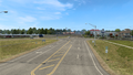
Gallery
View
Map


New Mexico
Gallup
Business Loop 31 (BL 31) is a retired portion of business loop that ran through Gallup in western New Mexico.[1] In real-life and in-game altogether, the route is still acknowledged on highway guide signs. Its western terminus is at a minor road in the southwestern limits of the city. It follows the former US 66 across the southern city limits to the east, intersecting other roads, including a couple of access roads serving Muñoz Boulevard to Interstate 40 and US 491. The route continues to the east until it reaches its eastern terminus with I-40 at exit 26. From there, the former US 66 continues to the east.
| mi | km | Destinations | Facilities | Notes |
|---|---|---|---|---|
| 0 | 0 | Minor road | Western terminus in-game | |
| 0 | 0 | Minor road | Access to I-40 and US 491 via Muñoz Boulevard | |
| 0 | 1 | Fusion Travel Plaza | ||
| 0 | 1 | Secret road | ||
| 1 | 1 | Minor road | Access to I-40 and US 491 via Muñoz Boulevard | |
| 1 | 2 | Service Shop | ||
| 1 | 2 | Minor road | ||
| 1 | 2 | Minor road | Access to US 491 | |
| 8 | 13 | I-40 exit 26 | ||
| Eastern terminus |
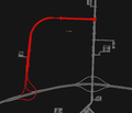
Gallery
View
Map


Santa Rosa
Business Loop 35 (BL 35) is a business loop in Santa Rosa in eastern New Mexico. The route beings at exit 273 of Interstate 40 and traces to the southeast towards its junction with US 54, and soon afterwards, run a concurrency with the highway. Between I-40 exit 273 and US 54, it runs a concurrency with US 84. BL 35 turns to the east and intersects I-40 for a second time, at exit 275. The route continues to run an east–west run through the Santa Rosa city limit, passes by a Rest Stop and turns to the south. BL 35 reaches its eastern terminus at, for the third time, I-40, at exit 277.
| mi | km | Destinations | Facilities | Notes |
|---|---|---|---|---|
| 0 | 0 | Western terminus; I-40 exit 273 | ||
| 5 | 9 | Western terminus of US 54 concurrency | ||
| 10 | 17 | I-40 exit 275 | ||
| 16 | 26 | Rest Stop | ||
| 18 | 29 | Eastern terminus of US 54 concurrency; I-40 exit 277 | ||
| Eastern terminus |
Gallery
View

Map


Tucumcari
Business Loop 36 (BL 36) is a business loop in Tucumcari in eastern New Mexico. It beings at a T-intersection with a minor road. In real-life, BL 35 continues to the west towards Interstate 40, whereas in ATS, the route simply ends there with no inaccessible continuation. The route traces to the east through the city and intersects NM 104 and US 54 before reaching its eastern terminus at I-40 at exit 335. From there, the road continues as a secret road, which follows the former US 66.
| mi | km | Destinations | Facilities | Notes |
|---|---|---|---|---|
| 0 | 0 | Minor road | Western terminus in-game | |
| 0 | 0 | |||
| 0 | 0 | Minor road | ||
| 0 | 1 | Minor road | ||
| 1 | 1 | Some I-40 route shields are mislabeled as I-40 BL | ||
| 1 | 2 | Eddy's Market | ||
| 6 | 10 | I-40 exit 335 | ||
| Secret road (Texas DLC required) |
Gallery
View
Map


Texas
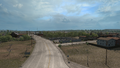
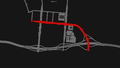
Glenrio
Business Interstate 40-A (Bus. I-40-A) is a business loop in Glenrio at the New Mexico–Texas state line, entirely within the state of Texas. The route beings at the state line with New Mexico towards Tucumcari and ends 10 miles (17 km) east of the state line, running parallel with Interstate 40. At its eastern terminus, the road continues as an I-40 Frontage Road towards Adrian, west of Amarillo.
The route and between the termini in ATS do not intersect I-40. In real-life, the eastern terminus is at exit 0 of I-40. The entire route is accessed by a secret road, which requires the New Mexico and Texas map expansions in order to access the road.
| Location | mi | km | Destinations | Facilities | Notes |
|---|---|---|---|---|---|
| Glenrio | 0 | 0 | Western terminus | ||
| 10 | 17 | I-40 Service Road | Eastern terminus in-game |
Gallery
View
Map

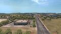
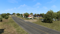
Adrian
Business Interstate 40-B (Bus. I-40-B) is a business loop in Adrian in the panhandle of northern Texas. The route runs an east–west run through the city limits, following the former US 66 and running parallel with Interstate 40. The western terminus of the route is at exit 22 of I-40, and its eastern terminus is at I-40, with the same exit number (22) in-game. Between the termini, Bus. I-40-B serves the Amarillo Vitas Power construction site access road, and the famous midpoint market of US 66.
| Location | mi | km | Destinations | Facilities | Notes |
|---|---|---|---|---|---|
| 0 | 0 | Western terminus; I-40 exit 22 | |||
| 6 | 9 | Minor road has access to Amarillo Vitas Power construction site to the north; I-40 exit 22 | |||
| Adrian | 6 | 10 | The city of Adrian | ||
| 7 | 12 | Minor road | |||
| 13 | 21 | I-40 Service Road | Eastern terminus; I-40 provides a westbound exit to this point towards Adrian |
Gallery
View
Map


Shamrock
Business Interstate 40-J (Bus. I-40-J) is a business loop in Shamrock in the panhandle of northern Texas. The route runs an east–west alignment through the city limits, following the former US 66 and running parallel with Interstate 40. The western terminus of the route is at exit 161 of I-40, which is only an exit to the business route. The eastern terminus is at I-40, east of US 83 at exit 163. Between the termini, Bus. I-40-J also serves the latter US route in the center of the town.
| Location | mi | km | Destinations | Facilities | Notes |
|---|---|---|---|---|---|
| 0 | 0 | I-40 Eastbound Exit | Western terminus; inbound access only | ||
| Shamrock | 6 | 10 | |||
| 13 | 21 | Eastern terminus |
Gallery
View
Map


Oklahoma
Clinton
Interstate 40 Business (I-40 Bus.) is a business loop in Clinton in western Oklahoma. The route follows Gary Boulevard and partially with Historic US 66. The western terminus is at exit 65 of Interstate 40 (with no eastbound access to the latter route) and heads north, passing the Route 66 Museum to the west, as well as a Plugged warehouse. The route curves to the east before terminating at US 183 in the downtown area of the city.
| mi | km | Destinations | Facilities | Notes |
|---|---|---|---|---|
| 0 | 0 | Western terminus; no access to I-40 eastbound; I-40 exit 65 | ||
| 1 | 2 | Clinton Plugged Warehouse | ||
| 4 | 7 | Eastern terminus in-game; I-40 Bus. continues east inaccessibly |
Gallery
View
Map


Sallisaw
Interstate 40 Business (I-40 Bus.) is a business loop in Sallisaw in eastern Oklahoma. The entire route follows a north–south alignemnt while being overlapped by US 59. The western terminus is at exit 308 of Interstate 40 and US 59. The route intersects the inaccessible Ruth Street before terminating at a rest stop, as well as US 59.
| mi | km | Destinations | Facilities | Notes |
|---|---|---|---|---|
| 0 | 0 | Western terminus; western terminus of US 59 concurrency; I-40 exit 308 | ||
| 2 | 4 | Ruth Street | Inaccessible | |
| 4 | 7 | Rest Stop | Eastern terminus in-game; eastern terminus of US 59 concurrency |
Gallery
View
Map


References
- ↑ Business Route 40 - Interstate-Guide.com (accessed 01-27-2023)
See also
| Cities | |
|---|---|
| Highways | Interstate 8 • Interstate 10 • Interstate 15 • Interstate 17 • Interstate 19 • Interstate 40 • US 60 • US 64 • US 70 • US 89 • US 89A • US 93 • US 95 • US 160 • US 163 • US 180 • US 191 • SR 51 • SR 61 • SR 64 • SR 66 • SR 77 • SR 85 • SR 89 • SR 90 • SR 92 • SR 98 • SR 260 • SR 303 • SR 389 |
| See also | |
| Cities | Alamogordo • Albuquerque • Artesia • Carlsbad • Clovis • Farmington • Gallup • Hobbs • Las Cruces • Raton • Roswell • Santa Fe • Socorro • Tucumcari |
|---|---|
| Highways | |
| See also | |
| Cities | |
|---|---|
| Highways | Interstate 35 • Interstate 40 • Interstate 44 • Interstate 235 • Interstate 244 • US 54 • US 56 • US 59 • US 60 • US 62 • US 64 • US 69 • US 70 • US 75 • US 77 • US 81 • US 83 • US 183 • US 259 • US 270 • US 271 • US 277 • US 281 • US 287 • US 377 • US 385 • US 412 • SH-1 • SH-3 • SH-7 • SH-8 • SH-9 • SH-15 • SH-31 • SH-34 • SH-66 • SH-99 • SH-136 • SH-142 • SH-259A • SH-375 |
| See also | List of scenery towns in Oklahoma • List of landmarks in Oklahoma - List of Truck Stops in Oklahoma |