US 57
U.S. Route 57 (US 57) is a north–south intrastate United States Highway that follows nearly an east–west route in southern Texas in American Truck Simulator. It runs from US 83 in La Pryor to Interstate 35 southwest of San Antonio.
US 57 is one of several rendered US Highways to run within a state in real life, along with US 96, US 181, US 290 and US 350, and it is currently the lowest numbered US Highway to run within a state in-game, which excludes such other highways that are considered to run "within" a state in ATS, but the rest of these routes has yet to introduce its other section(s) along its course through several other states that run within in real life.
Also, in real life, the southern (western) terminus of US 57 is at the Mexican border in Eagle Pass, while it gradually continues east to the route's physically-rendered southern terminus in ATS and ends at I-35, spanning a total length of 98 miles (158 km).
Course
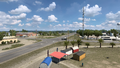
US 57, in real life, begins in Eagle Pass, but in ATS, it presently begins inaccessibly at an intersection with US 277. The highway, in-game, is relatively short, with only around half of the highway rendered east of US 83. The route begins at a four-way intersection at US 83 in La Pryor and travels eastward within the Brush Country in southern Texas. It passes by a cotton farm, owned by Mary's Cotton and as part of San Antonio, and it reaches its northern (eastern) terminus at Interstate 35 southwest of San Antonio.
Cities
- San Antonio (via I-35)
Scenery towns
Junction list
| Location | mi | km | Destinations | Facilities | Notes |
|---|---|---|---|---|---|
| La Pryor | 0 | 0 | Southern terminus in-game | ||
| 23 | 38 | San Antonio Mary's Cotton Plant | |||
| 30 | 49 | Northern terminus; facilities are served by I-35 Southbound Frontage Road; I-35 exit 111 |
Gallery
La Pryor
