US 89

|
This article needs a clean-up.
You can help Truck Simulator Wiki by re-organizing parts of the article, checking grammar / spelling, and doing other helpful things to correct the article.
|
U.S. Route 89 (US 89) is a north–south US Highway in northern Arizona, central Utah, southeastern Idaho, western Wyoming, and central Montana in American Truck Simulator. The route is separated into six sections: Interstate 40 Business and US 180 in Flagstaff to US 50 in Salina; US 6 in Spanish Fork to SR-52 in Orem, within Provo; SR-26 to 24th Street within Ogden; US 91 in Brigham City to US 20, US 191, and US 287 in Yellowstone National Park; Interstate 90 east of Bozeman to Interstate 15 at Great Falls; and US 2 in Browning to the Going to the Sun Road in St. Mary. In real life, US 89 runs a total of 1252 miles (2015 km) from Flagstaff, AZ, to the Canadian border north of Babb, MT. The route is split into two segments by Yellowstone National Park, where US highways are not numbered.
Course
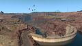
US 89 begins in Flagstaff, AZ, where it intersects with US 180. The 89 runs through the forests at the feet of the San Francisco Peaks (which include Humphreys Peak, the highest point of Arizona) to the red desert of the Colorado Plateau, where, at Cameron, AZ 64 intersects with the highway at a roundabout. North of Cameron the 89 meets US 160 at its western terminus, and after passing Bitter Springs it cuts through the Echo Cliffs and heads to Page. Out of Page the highway crosses the Colorado River via the Glen Canyon Dam Bridge, which is named after the hydroelectric dam beside it and the canyon the Colorado runs through at this point; with a height above the river of 700 feet (210 m), this is one of the highest bridges in the US. After crossing the canyon a viewpoint is offered, and shortly afterwards, past a southbound weigh station, the highway enters Utah.
After trending west through the colorful desert, at the base of the Vermillion Cliffs, US 89 reaches Kanab, where it intersects with US 89A. There the 89 continues north through the canyon of Kanab Creek, where there is a weigh station and a viewpoint at Moqui Cave. Out of the canyon the highway runs along the East Fork Virgin River for a ways before meeting UT 12. Joining the course of the Sevier River, the 89 runs through Panguitch and on to the Piute Reservoir. From there the highway runs through the gorge of the Sevier, where it passes the Deer Creek Rest Area (which features a viewpoint) and the Big Rock Candy Mountain Resort. Out of the gorge, the 89 meet Interstate 70, which it follows to Salina, where the southern section of US 89 in the game ends.
The highway is rejoined in Spanish Fork, where it intersects with US 6 and heads through Provo to UT-52 at Orem, where another gap in the road begins. The 89 is resumed in Ogden, which it runs through for a short distance before another gap. It is again rejoined at Brigham City, where it runs concurrent with US 91 between the Wellsville and Wasatch Mountains to the Cache Valley and the city of Logan. The 89 leaves Logan through the canyon of the Logan River, and crests the Bear River Mountains at Bear Lake Summit (7800 ft), where there is a rest area. The highway descends into the Bear Lake Valley and the town of Garden City, where it meets UT-30, which heads east into Wyoming. The 89 heads north along the shore of Bear Lake, which features a viewpoint, and enters Idaho, which the highway runs through for a relatively short distance. In Idaho, the 89 passes through the towns of Ovid and Montpellier, where, at the latter it intersects with US 30, which heads to McCammon.
Shortly after leaving Montpelier, the 89 enters Wyoming and crosses Salt River Pass (7620 ft), where the highway exits the Great Basin. Running to the west of the Salt River Range, the highway proceeds north through Star Valley to Alpine and Alpine Junction, where US 26 comes in from the west and begins running concurrent with the 89. From here the highway follows the Snake River through a canyon to Hoback Junction, where US 191 joins the concurrency. Soon afterwards, the highway runs through the town of Jackson, and continues through the valley known as Jackson Hole. Here a viewpoint provides a chance to get a good look at the Teton Range, a range of high, prominent, jagged mountains to the immediate west that provide a magnificent backdrop, crowned by the uniquely-shaped Grand Teton (13,775 ft/4199 m). At Moran, US 26 breaks away to the east, while US 287 joins the 89 and 191. The three highways enter Grand Teton National Park, where they skirt the edge of Jackson Lake, which has another majestic view of the Tetons. Soon the highways enter Yellowstone National Park, a very large and popular national park established on the caldera of a dormant supervolcano; in addition to having over half of the world's geysers and hydrothermal features, one of the few remaining populations of American bison, and to being a UNESCO World Heritage Site, Yellowstone is the oldest national park in the US, and possibly the world. Imnediately after entering Yellowstone, a wayside provides access to the Snake River, this point not being far from the river's headwaters. The highways soon reach West Thumb, where US 20 comes in from the east and becomes the fourth highway to follow this route. The highways then climb up the Yellowstone Plateau to Old Faithful Village, where there is a rest area. Between Yellowstone's south gate and this point, US 89 (and, for that matter, US 191 and 287) cross the Great Continental Divide three times. After passing alongside the Lower Geyser Basin and the Firehole River, and after crossing the Madison, US 89's course in Wyoming ends at Madison Junction, where it breaks away from the other highways.
US 89 resumes at its junction with Interstate 90 east of Bozeman, Montana. After crossing the Yellowstone River, it runs north through the Shields Valley, bound to the west by the Bridger Range and Big Belt Mountains, and to the east by the Crazy and Castle Mountains. US 12 joins the highway in the north of this valley, and runs concurrent as far as White Sulphur Springs. There the 89 continues over the Little Belt Mountains via Kings Hill Pass (7385 ft/2251 m) to Armington Junction, where it joins US 87 and MT 200; at the junction is a rest area with a weigh station. The highways proceed northwest through Great Falls, where US 87 breaks away. After crossing the Missouri River, US 89 ends this segment of its course at its junction with Interstate 15. The 89 resumes south of Browning, at its junction with US 2. The highways run concurrent through Browning and separate at a roundabout in the west of town, the 89 continuing north along the dramatic Lewis Range. The highway currently ends at the village of St. Mary, at the eastern end of the Going to the Sun Road.
Cities
Arizona
Scenery towns
Utah
Scenery towns
Wyoming
Scenery towns
Montana
Scenery towns
Junction list
Arizona
| Location | mi | km | Destinations | Facilities | Notes |
|---|---|---|---|---|---|
| Flagstaff | 0 | 0 | Verde St |
Southern terminus | |
| Cameron | 39 | 64 | |||
| 43 | 69 | Truck stop | Northbound only | ||
| 58 | 93-94 | ||||
| Bitter Springs | 95 | 154 | Bitter Springs | Inaccessible | |
| Page | 125 | 201 | |||
| 130 | 209 | Northern terminus in Arizona DLC | |||
| 132 | 213 | Glen Canyon Dam Bridge | |||
| 141 | 227 | Port of Entry | Southbound only |
Utah
| Location | mi | km | Exit | Destinations | Facilities | Notes |
|---|---|---|---|---|---|---|
| Kanab | 182 | 293 | Truck Stop | |||
| 189 | 305 | TOTSO | ||||
| 197 | 318 | Rest Stop | ||||
| 206 | 331 | Port of Entry | ||||
| 222 | 358 | The Moqui Cave | ||||
| 252-253 | 406-407 | Inaccessible | ||||
| Panguitch | 267-268 | 430-432 | Truck Stop | |||
| 270 | 434 | Inaccessible TOTSO | ||||
| 308 | 496 | The Hoover Rest Area | ||||
| 318 | 511 | Rest Stop | ||||
| 340 | 549 | 23 | South end of I-70 concurrency TOTSO | |||
| Salina | 378 | 608 | 56 | Truck Stop |
North end of I-70 concurrency South end of US 50 concurrency TOTSO | |
| 384 | 618 | Industrial Park | Access to Plaster & Sons and HMS Machinery depots | |||
| 384 | 618 | Western Star Trucks dealer | ||||
| 385 | 620 | North end of US 50 concurrency | ||||
| 386-387 | 621-622 | Sunshine Crops farm | ||||
| 387 | 623 | Bushnell Farms | ||||
| End of first section | ||||||
Beginning of second section | ||||||
| Spanish Fork | 387 | 623 | Truck Stop | |||
| 388 | 624 | TOTSO South end of US 6 concurrency | ||||
| 391 | 630 | TOTSO North end of US 6 concurrency | ||||
| Provo | 397 | 640 | Minor road | Access to Sunshine Crops farm | ||
| 401-402 | 646-648 | Coastline Mining quarry | ||||
| 406 | 655 | 300 South | TOTSO | |||
| 407 | 656 | University Ave | TOTSO | |||
| Orem | 409 | 658 | ||||
| End of second section | ||||||
Beginning of third section | ||||||
| Ogden | 409 | 658 | ||||
| 412 | 662 | 25th St | Access to Kenworth dealer and Rail Export depot | |||
| 414 | 666 | 24th St | ||||
| End of third section | ||||||
Beginning of fourth section | ||||||
| Brigham City | 414 | 666 | TOTSO
South end of US 91 concurrency | |||
| Logan | 430 | Access to Coastline Mining depot | ||||
| 430 | Southbound TOTSO Access to Coastline Mining depot | |||||
| 431 | South end of SR-30 concurrency | |||||
| 432 | TOTSO North end of US 91 / SR-30 concurrency Northern Terminus in Utah DLC | |||||
| 447 | Inaccessible | |||||
| 452 | Rest Area | |||||
| Garden City | 470 | TOTSO | ||||
| 478 | Bear Lake Marina | |||||
Idaho
| Location | mi | km | Destinations | Notes |
|---|---|---|---|---|
| Ovid | 500-501 | 804-807 | Two TOTSOs Inaccessible | |
| Montpellier | 519 | 835 | TOTSO Inaccessible | |
| 521 | 838 | TOTSO |
Wyoming
| Location | mi | km | Destinations | Facilities | Notes |
|---|---|---|---|---|---|
| 588 | 947 | Inaccessible | |||
| Alpine | 626 | 1007 | Alpine | ||
| Alpine Junction | 633 | 1019 | Port of Entry |
||
| 634-636 | 1020-1023 | Truck Stop | |||
| Hoback Junction | 659 | 1060 | South end of US 189 / US 191 concurrency | ||
| Jackson | 668 | 1075 | High School Rd | Access to Wallbert warehouse | |
| 668 | 1076 | South Park Loop Rd | Access to Deepgrove depot | ||
| 669 | 1076-1077 | Buffalo Way |
Access to Bushnell Farms depot | ||
| 669 | 1077 | Scott Ln | Access to Drake Car Dealer | ||
| 670 | 1078 | Gas Station | |||
| 670 | 1079 | Milward St | Access to Wallbert food market | ||
| 671 | 1080 | Cache St | TOTSO North end of US 189 concurrency | ||
| 691 | 1112 | Grand Teton National Park | |||
| Moran Junction | 709 | 1140 | North end of US 26 concurrency South end of US 287 concurrency TOTSO | ||
| Grand Teton National Park | 712 | 1145 | Grand Teton National Park entrance | Road closed to Commercial Vehicles. If on job, asked to turn around, with a $2,000 fee for not complying. $20 toll paid if not on job. (Fee not paid for Riverton to Jackson Special Transport job) | |
| Yellowstone National Park | 746 | 1201 | Yellowstone National Park entrance | Road closed to Commercial Vehicles. If on job, asked to turn around, with a $2,000 fee for not complying. $20 toll paid if not on job. (Fee not paid for Riverton to Jackson Special Transport job) Northbound only | |
| 751 | 1209 | Inaccessible South end of US 20 concurrency | |||
| 765 | 1232 | Old Faithful Administration Area | Northern terminus in game | ||
History
- In update 1.5, as part of the 1:35 to 1:20 map rescale, new sections were added to the existing route to accommodate the new map scale, including the scenery town of Bitter Springs.
- In update 1.35, the at-grade three-way junction with SR 64 in Cameron was changed to a four-way roundabout, and the truck stop and surrounding roads were rebuilt. The at-grade three-way junction with US 160 was rebuilt.
- In the initial version of the Utah map expansion DLC, the sections of US 89 from Page to Salina, from US 6 in Spanish Fork to SR-52 in Orem, from SR-26 to 24th Street within Ogden, and from US 91 in Brigham City to US 91 and SR-30 in Logan were added.
- In the initial version of the Wyoming map expansion DLC, the section of US 89 from US 91 and SR-30 in Logan to US 20, US 191, and US 287 in Yellowstone National Park was added.
Gallery
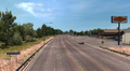
Flagstaff
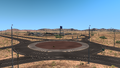
Cameron
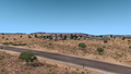
Bitter Springs
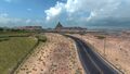
Page
Glen Canyon Bridge


See also
| Cities | |
|---|---|
| Highways | Interstate 8 • Interstate 10 • Interstate 15 • Interstate 17 • Interstate 19 • Interstate 40 • US 60 • US 64 • US 70 • US 89 • US 89A • US 93 • US 95 • US 160 • US 163 • US 180 • US 191 • SR 51 • SR 61 • SR 64 • SR 66 • SR 77 • SR 85 • SR 89 • SR 90 • SR 92 • SR 98 • SR 260 • SR 303 • SR 389 |
| See also | |
| Cities | Cedar City • Logan • Moab • Ogden (Roy) • Price • Provo (Mapleton, Orem, Spanish Fork) • Salina - Salt Lake City (Garfield, Herriman, Sandy, West Valley City) • St. George • Vernal |
|---|---|
| Highways | |
| See also | List of scenery towns in Utah • List of landmarks in Utah • List of Truck Stops in Utah |
| Cities | Boise (Eagle, Meridian) • Coeur d'Alene (Fernan Lake Village) • Grangeville • Idaho Falls • Ketchum (Sun Valley) • Lewiston • Nampa • Pocatello (Inkom) • Salmon • Sandpoint (Ponderay) • Twin Falls |
|---|---|
| Highways | |
| See also | |
| Cities | Casper (Brookhurst, Mills) • Cheyenne (Fox Farm-College, South Greeley) • Cody • Evanston • Gillette • Jackson • Laramie • Rawlins (Sinclair) • Riverton • Rock Springs • Sheridan |
|---|---|
| Highways | Interstate 25 • Interstate 80 • Interstate 90 • Interstate 180 • US 14 • US 14 Alternate • US 16 • US 18 • US 20 • US 26 • US 30 • US 85 • US 87 • US 89 • US 189 • US 191 • US 287 • US 310 • WYO 22 • WYO 28 • WYO 50 • WYO 51 • WYO 59 • WYO 76 • WYO 89 • WYO 94 • WYO 110 • WYO 120 • WYO 135 • WYO 150 • WYO 210 • WYO 212 • WYO 220 • WYO 222 • WYO 258 • WYO 339 • WYO 351 • WYO 374 • WYO 450 • WYO 487 • WYO 789 |
| See also | List of scenery towns in Wyoming • List of landmarks in Wyoming • List of Truck Stops in Wyoming |