US 56
U.S. Route 56 (US 56) is an east–west United States Highway in northeastern New Mexico and the Oklahoma panhandle in American Truck Simulator. It runs from US 64, US 87, and US 412 in Clayton to US 64, US 412, and SH-3 between Boise City and Guymon, concurrent with US 64 and US 412.
In real life, US 56 spans a total length of 640.25 miles (1,030.38 km) from Springer, New Mexico to Kansas City, Missouri.
Course
The western terminus of US 56, as well as US 412, is at the junction with US 64 and US 87 in Clayton in northeastern New Mexico. The highway follows a concurrency with the 64 and 412 towards the northeast as it passes by a rest stop, just northeast of town, as well as the northwestern corner of Texas.
US 56 in Oklahoma cuts across the western part of the state's panhandle shortly afterwards. The highway continues to run concurrently with US 64 and US 412 as it traverses across the Rita Blanca National Grasslands upon intersecting US 385, which the latter also overlaps the highway into Boise City. In Boise City, the 56 approaches a roundabout encircling the Cimarron County Courthouse (which also features a viewpoint) that involves US 56, US 64, US 385, US 412, SH-3, and SH-325. US 56 turns east, which then SH-3 joins the latter highways overlapping the 56 and serves a truck stop and a weigh station before intersecting US 287 east of Boise City. The highway begins to run parallel with a railroad upon reaching its current eastern terminus at US 64, US 412, and SH-3 between Boise City to the west and Guymon to the east, which will eventually continue into Kansas as a separate section from its current east end according to ATS's usa.dds file for the map editor.
Cities
New Mexico
Scenery towns
Oklahoma
Scenery towns
Junction list
New Mexico
| Location | mi | km | Destinations | Facilities | Notes |
|---|---|---|---|---|---|
| Clayton | 0 | 0 | Western terminus in-game; western terminus of US 64 and US 412 concurrencies; US 56 continues west inaccessibly; US 412 westbound is inaccessible | ||
| 7 | 11 | Rest Area | Eastern terminus in New Mexico DLC |
Oklahoma
| Location | mi | km | Destinations | Facilities | Notes |
|---|---|---|---|---|---|
| 37 | 60 | Western terminus in Oklahoma DLC; western terminus of US 385 concurrency | |||
| Boise City | 48 | 78 | TOTSO; Viewpoint within roundabout; eastern terminus of US 385 concurrency; western terminus of SH-3 concurrency; SH-325 is inaccessible; one route marker mislabel SH-325 as US 325 | ||
| 54 | 87 | Phoenix Truck Stop | |||
| 57 | 92 | Weigh Station | |||
| 64 | 103 | US 287 southbound is inaccessible | |||
| 89 | 143 | Eastern terminus in-game; eastern terminus of US 64, US 412 and SH-3 concurrencies; US 56 continues northeast inaccessibly |
History
- In update 1.48, as part of the reassignment of US 64 and US 87 in northeastern New Mexico, first added in the initial version of the Texas map expansion DLC, to the New Mexico map expansion DLC, US 56 began at US 64, US 87, and US 412 in Clayton and ended at a rest area northeast of Clayton, concurrent with US 64 and US 412. US 56 was inaccessible before then.
Gallery
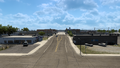
Clayton
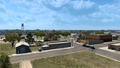
Boise City


See also
| Cities | Alamogordo • Albuquerque • Artesia • Carlsbad • Clovis • Farmington • Gallup • Hobbs • Las Cruces • Raton • Roswell • Santa Fe • Socorro • Tucumcari |
|---|---|
| Highways | |
| See also | |
| Cities | |
|---|---|
| Highways | Interstate 35 • Interstate 40 • Interstate 44 • Interstate 235 • Interstate 244 • US 54 • US 56 • US 59 • US 60 • US 62 • US 64 • US 69 • US 70 • US 75 • US 77 • US 81 • US 83 • US 183 • US 259 • US 270 • US 271 • US 277 • US 281 • US 287 • US 377 • US 385 • US 412 • SH-1 • SH-3 • SH-7 • SH-8 • SH-9 • SH-15 • SH-31 • SH-34 • SH-66 • SH-99 • SH-136 • SH-142 • SH-259A • SH-375 |
| See also | |