Eddy County Administration Complex

First National Bank of Eddy
Pecos River
Carlsbad (New Mexico)
Jump to navigation
Jump to search
Carlsbad is a city featured in the New Mexico map expansion for American Truck Simulator.[1]
Summary
Carlsbad is located in southeastern New Mexico, south of Artesia and west of Hobbs. In real life, it is known for its caverns.
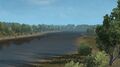
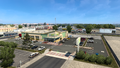
Most of Carlsbad's amenities are located at the city center at the intersection of the US 62 and the US 285 with others located on the other side of the Pecos River. In the city center are two Voltison Motors depots, one Tidbit depot, a rest stop, and a recruitment agency. Across the river in a more rural part of the city is a gas station and a Plaster & Sons depot.
Features
Depots
- Voltison Motors depots (x2)
- Tidbit depot
- Plaster & Sons depot
Facilities
Landmarks
- "Welcome to Carlsbad" entrance sign
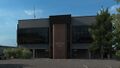
- Eddy County Administration Complex
- First National Bank of Eddy
- Pecos River
Connections
- The
 and
and  run west to El Paso, Texas and east to Hobbs.
 - The
 runs southeast to Pecos and Fort Stockton, Texas and north to Artesia.
Media
Gallery


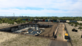
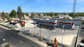
Plaster & Sons
Tidbit
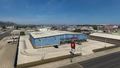
Voltison Motors car dealer
Voltison Motors warehouse


See also
References
- ↑ New Mexico map, Moh1336 in SCS Blog Discussion, SCS Software Forum, 2017-11-03 (accessed 2017-11-03)
| Cities | Alamogordo • Albuquerque • Artesia • Carlsbad • Clovis • Farmington • Gallup • Hobbs • Las Cruces • Raton • Roswell • Santa Fe • Socorro • Tucumcari |
|---|---|
| Highways | |
| See also | |