TX 31
State Highway 31 (SH 31) is an east–west state highway in central and northeastern Texas in American Truck Simulator. It runs from Loop 340 in Bellmead to Loop 323 in Tyler.
In real life, SH 31 spans a total length of 149.813 mi (241.101 km) from nearby Bellmead to Longview, Texas.
Course
In real life, SH 31 begins at US 84 northeast of Bellmead, whereas in ATS, the western terminus is at Loop 340 in the town, omitting a section of the 84 nearby Waco. The highway traces north across the Texas Blackland Prairies as it makes its way into the city of Corsicana, where a viewpoint is passed, showcasing the city, and intersects Interstate 45 east of that; soon afterwards, the highway enters the town of Powell. Just east of town, SH 31 crosses Cedar Creek and traverses through a wetland at the creek with a rest stop in the median of the highway. At this point, the highway begins to mostly run an east–west orientation as it begins to trace through the Piney Woods. It runs through Chandler before entering the city of Tyler, where it reaches its eastern terminus at Loop 323.
Cities
Junction list
| Location | mi | km | Destinations | Facilities | Notes |
|---|---|---|---|---|---|
| Bellmead | 0 | 0 | Western terminus in-game; southern terminus of Loop 340; Loop 340 southbound is inaccessible; FM 2418 is inaccessible | ||
| 0 | 1 | Vortex Gas Station | |||
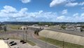
| Corsicana | 28 | 46 | Gallon Oil Gas Station / The city of Corsicana | ||
| 36 | 58 | Minor road | Access to Dallas Azure Glasswork plant and Faraday electric substation | ||
| 39 | 64 | I-45 exit 231 | |||
| 77 | 123 | Picnic Area | |||
| Tyler | 102 | 164 | Tyler Olthon Homes Depot | ||
| 102 | 165 | Service shop | |||
| 103 | 165 | Eastern terminus in-game; SH 31 continues east inaccessibly |
Gallery
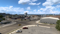
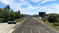
Bellmead
Corsicana
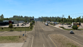
Powell
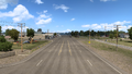
Chandler
Tyler


