US 190
U.S. Route 190 (US 190) is an east–west United States Highway in Texas in American Truck Simulator. The route is separated into five sections: The first section runs from Interstate 10 and FM 305 east of Fort Stockton to a Petrolucent oil well north of I-10, concurrent with FM 305. The second section runs from US 183 and US 281 in Lampasas to Interstate 35 in Belton, mostly concurrent with Interstate 14. The third section runs from US 77 and SH 36 in Cameron to SH 30 and FM 1791 west of Huntsville. The fourth section runs from SH 75 and FM 1791 to SH 30, entirely within Huntsville, concurrent with Interstate 45. The fifth section runs from SH 19 east of Huntsville to east of US 96 in Jasper.
In real life, US 190 spans a total length of 875 miles (1,408 km) from nearby Iraan, Texas to Slidell, Louisiana.
Course
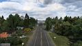
US 190, along with the southern terminus of FM 305, beings at Interstate 10 east of Fort Stockton and runs parallel with US 67 and US 385 to the northeast. The highway also overlaps with FM 305 from its western terminus to a wind farm and an oil well, owned by Petrolucent and Vitas Power respectively as part of Fort Stockton; there, the first gap of the highway begins here. US 190 resumes at the junction with US 183 and an inaccessible section of US 281 in Lampasas and heads east through the Killeen–Temple–Fort Hood metropolitan area, where it overlaps the entirety of Interstate 14 through Killeen, Harker Heights, and until it reaches its second gap in the route at Interstate 35 in Belton. Resuming in Cameron, the highway overlaps with US 77 and SH 36 as it continues to head east until the 77 branches off US 190; SH 36 simply ends there. The highway traverses across the Brazos Valley as it makes its way to Huntsville, where two gaps in the route are presented there. The first gap through the city starts at the junction with SH 30 and FM 1791, and US 190 resumes at exit 117 of Interstate 45 at SH 75 and FM 1791, northwest of Huntsville. The highway overlaps with I-45 to the south until it reaches its second gap (fourth gap overall) at SH 30 at exit 116. US 190 once again resumes east of Huntsville at SH 19 and departs the city limits through the Piney Woods of eastern Texas. Nearby Point Blank, a viewpoint is presented at Lake Livingston, which is also where US 190 crosses the lake and into Onalaska; soon afterwards, it intersects US 59 in Livingston. The highway enters the town of Indian Springs and runs through the Alabama-Coushatta Indian Reservation into Woodville, where it intersects with US 69 and US 287. US 190 bisects B. A. Steinhagen Reservoir, a major reservoir located on the Neches River, and begins overlapping SH 63 at a rest stop upon entering Jasper. Beyond intersecting US 96, the highway reaches its eastern terminus at a truck stop, to eventually continue into Louisiana.
Cities
- Fort Stockton (via I-10)
- Waco (via I-35)
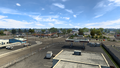
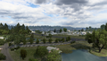
- Huntsville
Scenery towns
Junction list
| Location | mi | km | Destinations | Facilities | Notes |
|---|---|---|---|---|---|
| 0 | 0 | Western terminus; southern terminus of FM 305 concurrency | |||
| 9 | 15 | Fort Stockton Vitas Power Construction Site | |||
| 13 | 21 | Fort Stockton Petrolucent Oil Well | Northern terminus of FM 305 concurrency; US 190 and FM 305 continue east inaccessibly | ||
| End first section; start second section | |||||
| Lampasas | 13 | 21 | US 183 southbound and US 281 are inaccessible | ||
| 20 | 33 | Western terminus of I-14 concurrency; inaccessible | |||
| See | |||||
| Belton | 68 | 109 | Eastern terminus of I-14 concurrency; road continues as I-35; I-14 exit 300; I-35 exit 293 | ||
| End second section; start third section | |||||
| Cameron | 68 | 109 | Western terminus of US 77 and SH 36 concurrencies; US 190 and SH 36 continue east inaccessibly | ||
| 85 | 138 | Eastern terminus of US 77 and SH 36 | |||
| 135 | 218 | Road continues as SH 30; FM 1791 is a secret road; facilities are served by the secret road | |||
| End third section; start fourth section | |||||
| Huntsville | 135 | 218 | Western terminus of I-45 concurrency; road continues as I-45; I-45 exit 117 | ||
| 155 | 249 | Eastern terminus of SH 30; eastern terminus of I-45 concurrency; I-45 exit 116; US 190 and SH 30 continue east inaccessibly | |||
| End fourth section; start fifth section | |||||
| Huntsville | 155 | 249 | US 190 continue west inaccessibly | ||
| 158 | 254 | Huntsville Taylor Construction Site | |||
| Point Blank | 171 | 275 | Lake Livingston | ||
| Livingston | 193 | 311 | |||
| 202 | 326 | Inaccessible | |||
| Indian Springs | 217 | 349 | Alabama Coushatta Indian Village | Inaccessible | |
| Woodville | 227 | 365 | |||
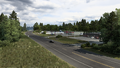
| Jasper | 254 | 408 | Rest Stop | Western terminus of SH 63 concurrency | |
| 256 | 412 | ||||
| 262 | 423 | Aron Truck Stop | Eastern terminus; eastern terminus of SH 63 | ||
Gallery
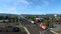
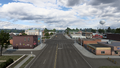
Lampasas
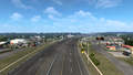
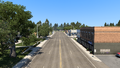
Killeen
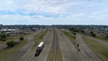
Harker Heights
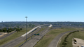
Belton
Cameron
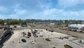
Huntsville
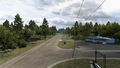
Point Blank
Onalaska
Livingston
Indian Springs
Woodville
Jasper


