TX 146
State Highway 146 (SH 146) is a north–south state highway in eastern Texas in American Truck Simulator. It runs from SPH 1 in Seabrook to due north of Interstate 10 in Mont Belvieu.
In real life, SH 146 spans a total length of 105.966 miles (170.536 km) from Texas City to Livingston, Texas.
Course
SH 146 serves the eastern part of central Greater Houston with Houston's port and many other small cities along the Galveston Bay. The highway begins at SPH 1 in Seabrook and travels north as a freeway towards a major interchange at Port Road, which serves the port of Houston to the east (including a Syntetico chemical plant) and the Johnson Space Center to the west (which SPH 1 also serves the area). The highway turns back into a boulevard as it enters Baytown; soon after crossing Interstate 10, it reaches its northern terminus at a truck stop in Mont Belvieu.
Cities
Junction list
| Location | mi | km | Destinations | Facilities | Notes |
|---|---|---|---|---|---|
| Seabrook | 0 | 0 | Southern terminus in-game; eastern terminus of SPH 1; SH 146 continues south inaccessibly | ||
| 4 | 7 | Port Road – Port of Houston Bayport Terminal | Access to Space Park Houston via Bay Area Boulevard | ||
| Baytown | 18 | 28 | Houston Wallbert Market | ||
| 18 | 29 | Minor road | Access to Houston Wallbert market | ||
| 18 | 29 | Gallon Oil Truck Stop | |||
| Mont Belvieu | 18 | 30 | I-10 exit 797 | ||
| 22 | 35 | Aron Truck Stop | Northern terminus in-game; SH 146 continues north inaccessibly |
Gallery
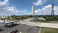
Seabrook
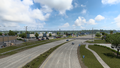
Baytown
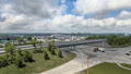
Mont Belvieu


