Interstate 69
Interstate 69 (I-69) is a north–south Interstate Highway in eastern Texas in American Truck Simulator. The entire length of the highway runs within Greater Houston in the game, with both terminus' ending at US 59 southwest of Houston and north of Humble, concurrent with the latter route.
In real-life, I-69 exists as a highway of several distinct sections, with a length of 841.3 miles (1,359 km) surfaced as of February 2023. The existing and current sections of I-69 run from Rosenburg to Cleveland, Texas; east of Banks, Mississippi to Memphis, Tennessee; Mayfield to Henderson, Kentucky; Evansville to Bargersville, Indiana; and Indianapolis, Indiana to Port Huron, Michigan. The remaining sections south of Victoria (with Interstates 69E and 69W to split I-69) to Rosenberg, Texas; Cleveland, Texas through northwestern Louisiana and southern Arkansas, along the Mississippi River to Banks, Mississippi; Memphis, Tennessee to Mayfield, Kentucky; across the Ohio River between Henderson, Kentucky and Evansville, Indiana; and in Indianapolis, Indiana have yet to be completed in the future to finish the entire route.
Course
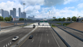
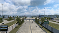
Interstate 69 beings at a point along the US 59 freeway at the southwestern city limits of Houston, overlapped by the same road. The highway traces to the east as a sunken freeway through the suburban areas in the southern city limits. It intersects SH 288, and shortly afterwards, intersects Interstate 45. At this point, I-69 turns to the northeast and passes Houston's downtown to the west; soon afterwards, it intersects Interstate 10 and US 90 northeast of downtown. I-69 continues to trace to the north, leaving Houston and entering Humble. There, it passes by the Houston Intercontinental Airport and intersects FM 1960, and soon after leaving Humble, I-69 ends at an intersection, where US 59 continues to the north towards Lufkin.
Cities
Exit List
| Location | mi | km | Exit | Destinations | Facilities | Notes |
|---|---|---|---|---|---|---|
| Houston | 0 | 0 | Southern terminus; road continues as US 59; southern terminus of US 59 concurrency | |||
| 4 | 6 | 126 | Shepherd Drive / Greenbriar Driver | Southbound exit and northbound entrance; Inaccessible | ||
| 15 | 24 | 128 | Inaccessible | |||
| 19 | 31 | 129 | I-45 exit 46 | |||
| 37 | 60 | 132 | I-10 exits 770 A-B | |||
| Humble | 64 | 103 | 149 | FM 1960 eastbound is inaccessible | ||
| 86 | 139 | Northern terminus; road continues as US 59; northern terminus of US 59 concurrency |
Gallery
Houston
Humble

