TX 87
State Highway 87 (SH 87) is a north–south state highway in eastern Texas in American Truck Simulator. It runs from Interstate 45 and SH 275 in Galveston to SH 124 in Bolivar Peninsula. The highway also runs across Galveston Bay, near the Gulf of Mexico, by ferry from Galveston to Bolivar Peninsula.
In real life, SH 87 consists of two separate sections, spanning a total length of 249.39 miles (401.35 km) from Galveston to Timpson, Texas, with its gap located between Bolivar Peninsula and Port Arthur.
Course
SH 87 begins at the southern terminus of Interstate 45, as well as the western terminus of SH 275 in western Galveston. The highway follows Broadway (or Avenue J) to the east as it travels near downtown, as well as passing by the Texas Heroes Monument in the middle of the intersection serving the highway and Rosenburg Avenue (25th Street). It turns northward to meet the eastern terminus of SH 275 before crossing Galveston Bay via ferry, landing on Bolivar Peninsula. The highway travels east between Galveston Bay to the north and the Gulf of Mexico to the south across the peninsula, with a Nielsen Roads roadworks near the ferry, and reaches its northern terminus at the curve at High Island Beach, which transitions to SH 124 towards Winnie and Interstate 10.
Cities
Scenery towns
- Bolivar Peninsula
- Winnie (via SH 124)
Junction list
| Location | mi | km | Destinations | Facilities | Notes |
|---|---|---|---|---|---|
| Galveston | 0 | 0 | Southern terminus; southern terminus of I-45; road continues as I-45 | ||
| Western terminus of SH 275; I-45 exit 1 | |||||
| 0 | 0 | 43rd Street | Inaccessible | ||
| 0 | 1 | Rosenberg Avenue (25th Street) | Inaccessible | ||
| 1 | 1 | Christopher Columbus Boulevard | Inaccessible | ||
| 1 | 2 | 6th Street / Seawall Boulevard | Inaccessible | ||
| 2 | 4 | Eastern terminus of SH 275 | |||
| 4 | 6 | ||||
| Bolivar Peninsula | 11 | 17 | Galveston Nielsen Roads Roadworks | Dynamic prefab | |
| 15 | 25 | Northern terminus in-game; southern terminus of SH 124; road continues as SH 124; Public Beach Access Road is inaccessible | |||
Gallery
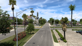
Galveston
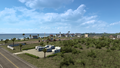
Bolivar Peninsula


Trivia
- SH 87, in real life, is notable for its stretch (now the gap between Bolivar Peninsula and Port Arthur) that has been washed out repeatedly over the decades and has been closed continuously since 1990. It was also left in a state of disrepair after the storm surge from Hurricane Jerry, which made landfall on October 15, 1989, causing minor damage in Texas.