US 82
U.S. Route 82 (US 82) is an east–west United States Highway in southeastern New Mexico and northern Texas in American Truck Simulator. The route is separated into two sections: The first section runs from US 54 and US 70 in Alamogordo to NM 18 in Hobbs. The second section runs from US 62 in Lubbock to due east of Interstate 30 in New Boston.
In real life, US 82 spans a total length of 1,625 miles (2,615 km) from Alamogordo, New Mexico to Brunswick, Georgia.
Course
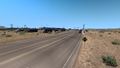
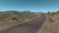
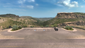
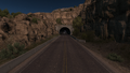
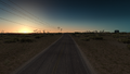
US 82 begins at an intersection with the concurrency of US 54 and US 70 in northern Alamogordo with a truck stop provided there. The highway heads east and accends into the Sacramento Mountains as it climbs the steep Mexican Canyon, where its section in this area is among one of the most scenic routes in New Mexico. It passes by the Tunnel Vista Observation Site, where a viewpoint is presented, and a tunnel is presented afterwards. The highway enters Lincoln National Forest and winds through the preserved area after passing by Mountain Park. The highway enters the western edge of the broad Pecos River valley and intersects US 285 in Artesia. As the highway traces across the Chihuahuan Desert, it runs through an oil field with many wells surrounding the road; here, it intersects NM 529 as it begins to trace across the Llano Estacado, a large plain covering eastern New Mexico and northwestern Texas. The highway enters Hobbs, where it intersects NM 18, and the gap in the route begins here.
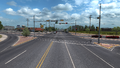
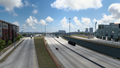
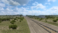
Across the state line from New Mexico, the highway resumes at an incomplete-accessed interchange served by US 62 in western Lubbock in northwestern Texas. As it traces through the city, it follows concurrently with the 62, intersecting US 84 and the overlapped highways of Interstate 27 and US 87. As the highway leaves Lubbock to the east, a gap of US 62 begins here, ending the concurrency of the latter route, and starts its concurrency with SH 114. The two highways traverse through the Caprock Escarpment, the eastern escarpment of the Llano Estacado, and crosses Blanco Canyon, where it also crosses White River nearby Silver Falls; there, a rest area is presented with the same name of the falls. The highway begins to trace through the rolling hills of northwestern Texas and passes by a second rest area; soon afterwards, it intersects US 83 in Guthrie. A third rest area is passed and enters Seymour, where SH 114 ends its concurrency with the 82 and merges with US 277 until it breaks off in Wichita Falls, where it then merges with US 287. At this point, US 82 begins to run parallel with the Red River and Oklahoma, the bordering state north of the river, and traces across the Red River valley. The highway branches off of the 287 east of Wichita Falls and traverses through hilly terrain south of the Red River. It runs through Saint Jo, and soon afterwards, it approaches Gainesville, where it intersects the overlapped highways of Interstate 35 and US 77. The surrounding forests become more denser as the 82 continues east towards its junction with US 75 in Sherman, and further east of the said town, it also intersects US 69. At this point, the highway has reached about two thirds of its entire length as it continues to parallel the Red River and Oklahoma. US 82 enters Paris, where it follows a similar course to the northern sections of Loop 286 in real life, while the latter route's existence in ATS is not present, as well as intersecting US 271; the population center of Paris can also be seen south of the interchange. Approaching the town of De Kalb, the 82 crosses US 259 before serving the town center; soon afterwards, it intersects Interstate 30 in New Boston before terminating at a Chuck & Jack's sawmill, shown as part of Texarkana.
Cities
New Mexico
Scenery towns
Texas
- Lubbock
- Wichita Falls
- Texarkana (via I-30)
Scenery towns
Junction list
New Mexico
| Location | mi | km | Destinations | Facilities | Notes | |
|---|---|---|---|---|---|---|
| Alamogordo | 0 | 0 | Western terminus | |||
| 0 | 0 | Gallon Oil Truck Stop | ||||
| 41 | 66 | US-82 rest area | ||||
| Artesia | 116 | 187 | Minor road | |||
| 116 | 188 | Minor road | ||||
| 117 | 188 | Minor road | ||||
| 117 | 188 | |||||
| 117 | 188 | Aron Gas Station | ||||
| 117 | 189 | Aron Gas Station | ||||
| 117 | 189 | Minor road | ||||
| 118 | 190 | Minor road | ||||
| 147 | 236 | Western terminus of NM 529; NM 529's direction is mislabeled as "South" | ||||
| Hobbs | 176 | 283 | Hobbs Charged Market | |||
| 177 | 285 | |||||
| End first section | ||||||
Texas
| Location | mi | km | Exit | Destinations | Facilities | Notes |
|---|---|---|---|---|---|---|
| Start second section | ||||||
| Lubbock | 177 | 285 | ---- | Texas Tech Parkway | Eastbound exit and westbound entrance; western terminus of US 62 concurrency; inaccessible | |
| 199 | 320 | ---- | US 84 eastbound is inaccessible | |||
| 211 | 341 | ---- | I-27 exit 4 | |||
| 230 | 371 | Lubbock Petrolucent Drilling Site | Eastern terminus of US 62 concurrency; western terminus of SH 114 concurrency | |||
| 247 | 399 | ---- | Silver Falls Rest Area | Eastbound only | ||
| 294 | 473 | ---- | Dickens County Rest Area | Westbound only | ||
| Guthrie | 313 | 504 | ---- | |||
| 344 | 555 | Knox County Safety Rest Area | ||||
| Seymour | 377 | 608 | TOTSO; FM 422 is inaccessible | |||
| 382 | 615 | Eastern terminus of SH 114 concurrency; SH 114 eastbound is inaccessible | ||||
| 384 | 618 | ---- | TOTSO; western terminus of US 277 concurrency | |||
| 421 | 677 | Inaccessible | ||||
| 423 | 681 | Wichita Falls Golden Meadows Farm | ||||
| Wichita Falls | 429 | 691 | ---- | Lawrence Road / Lebanon Road | ||
| 440 | 708 | ---- | TOTSO; eastern terminus of US 277 concurrency; western terminus of US 287 concurrency | |||
| 450 | 724 | ---- | Windthorst Road | |||
| 463 | 745 | ---- | TOTSO; eastern terminus of US 287 concurrency | |||
| 494 | 796 | Rest Stop | ||||
| Saint Jo | 504 | 812 | Inaccessible | |||
| Gainesville | 525 | 846 | I-35 exit 498 | |||
| 528 | 851 | Culberson Street / Gallon Oil Truck Stop | Access to Fort Worth Grand Pastures livestock auction | |||
| 529 | 853 | Weaver Street | Inaccessible | |||
| 530 | 855 | ---- | Minor road | Eastbound exit and westbound entrance; inaccessible | ||
| Sherman | 551 | 889 | 642 | US 75 exit 62; FM 131 is inaccessible | ||
| 570 | 918 | 653 | US 69 northbound is inaccessible | |||
| Paris | 621 | 1,001 | ---- | Southern terminus of US 271; US 271 southbound is inaccessible | ||
| De Kalb | 670 | 1,079 | ||||
| 674 | 1,086 | Inaccessible | ||||
| New Boston | 685 | 1,104 | I-30 exit 199 | |||
| 690 | 1,112 | Gallon Oil Truck Stop | ||||
| 694 | 1,119 | Texarkana Chuck & Jack's Sawmill | Eastern terminus in-game; US 82 continues east inaccessibly | |||
History
- In the initial version of the New Mexico map expansion DLC, US 82 began at US 54 and US 70 in Alamogordo and ended at NM 18 in Hobbs.
- In the initial version of the Texas map expansion DLC, the section of US 82 from US 62 in Lubbock to due east of Interstate 35 and US 77 in Gainesville was added.
- In update 1.48, the section of US 82 from Gainesville to due east of Interstate 30 in New Boston was added.
Trivia
- In the initial release of the Texas map expansion DLC, a small network of roads was discovered in the northeastern portion of the state beyond Dallas, Tyler and Longview, including an unfinished section of US 82 between Gainesville and Interstate 30 near Texarkana. Originally, the northern section of Loop 286 in Paris was planned to be featured with three interchanges along its route.[1] The system of roads was later removed in update 1.47, and with the release of update 1.48, Loop 286 was obsolete from the game, with only one diamond interchange rendered at the junction with US 82 and US 271 in Paris.
Gallery
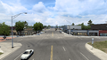
Alamogordo
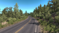
Sacramento Mountains
Tunnel Vista Observation Site
Tunnel near Mountain Park
Mountain Park
Lincoln National Forest
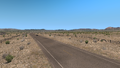
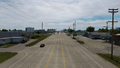
Plains near Artesia
Artesia
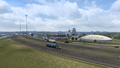
Oil field between Artesia and Hobbs
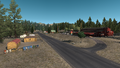
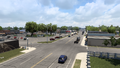
Hobbs
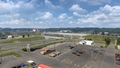
Lubbock
Silver Falls Park

Guthrie
Seymour
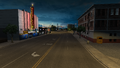
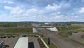
Wichita Falls
Saint Jo
Gainesville
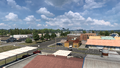
Sherman
Paris
De Kalb
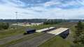
New Boston


References
- ↑ Texas Discussion Thread, Page 790, Message #7896 in SCS Forums, 2022-11-15 (accessed 2022-11-16)
See also
| Cities | Alamogordo • Albuquerque • Artesia • Carlsbad • Clovis • Farmington • Gallup • Hobbs • Las Cruces • Raton • Roswell • Santa Fe • Socorro • Tucumcari |
|---|---|
| Highways | |
| See also | |