US 20

|
This article needs a clean-up.
You can help Truck Simulator Wiki by re-organizing parts of the article, checking grammar / spelling, and doing other helpful things to correct the article.
|
U.S. Route 20 (US 20) is an east–west US Highway in central Oregon, southern Idaho and Montana, and central Wyoming in American Truck Simulator. The route is separated into two sections: The first section runs from US 101 in Newport to OR 201 in Ontario. The second section runs from US 26 and Can-Ada Road in Nampa to US 18 in Orin.
In real life, US 20 is the longest US route in the United States from Newport, Oregon to Boston, Massachusetts, a distance of 3365 miles (5415 km).
Course
US begins in Newport, OR, at its intersection with US 101. It crosses the Central Oregon Coast Range, where a Page & Price Paper mill and a Deepgrove logging site branch from the road, before entering the Willamette Valley, where it intersects with Interstate 5 at Albany. The highway then crosses the Cascade Range via Tombstone Pass, where another Deepgrove logging site is located, and descends past Black Butte to Bend, where it intersects with US 97. The 20 runs below Pilot Butte out of Bend and enters the scrublands of the Harney Basin, a northern extension of the Great Basin. Past the ghost town of Millican and the rest area at Brothers, passing below the Blue Mountains to the north, the highway reaches Riley, where US 395 begins a concurrency that ends north of Burns. The 20 proceeds past Buchanan and across the arid hills through Juntura, after which it runs along the Malhuer River through its gorge. The highway enters the Treasure Valley at Vale, where it intersects with the historic Oregon Trail, and proceeds across farmlands to its intersection with OR 201, where this segment ends, the 201 heading north to Ontario.
US 20 resumes at its intersection with N Can-Ada Road in the farmlands north of Nampa, ID, where it runs concurrent with US 26. At Eagle the highway intersects with ID-55, and shortly thereafter runs through downtown Boise, Idaho's capital and largest city. The 20 runs concurrent with Interstate 84 from Boise to Mountain Home, where it also breaks from the 26. Out of the Snake River Plain, the highway runs along the edge of the Danskin Mountains and the Mount Bennett Hills, along the way passing historical markers for Castle Rock and Goodale's Cutoff (an alternate route of the Oregon Trail that is roughly followed here). The highway then enters the Camas Prairie, where it intersects with ID-75, and soon after passes through the town of Carey, where it meets with US 26 and US 93. The three highways all run concurrent along the southern edge of the Pioneer Mountains, a range of the Northern Rocky Mountains, and pass along the northern boundary of Craters of the Moon National Monument and Preserve, an old volcano field that offers a viewpoint. At Arco the 93 breaks off, and the 20 and 26 run through the Snake River Plain, past the Idaho National Laboratory (a government lab complex specializing in nuclear energy), where US 26 soon after breaks away. After then running through the north of Idaho Falls, the highway heads north east and enters Montana.
From Idaho Falls, US 20 heads northeast through woodlands before it enters Island Park and crosses the river, Henrys Fork, three times before passing through Macks Inn. After passing through these areas, the 20 climbs the Targhee Pass and crosses the Continental Divide, where it then enters Montana. In Montana, US 20 passes through West Yellowstone, where it meets up with US 191 and US 287 before entering Wyoming and Yellowstone National Park. Tracing further east, US 20 meets up with US 89 at Madison Junction and heads south past Fountain Paint Pots to the ranger village and park maintenance facility at Old Faithful. Running concurrent with US Highways 89, 191, and 287, the highway descends from the Yellowstone Plateau over Duck Lake and breaks from the other highways at West Thumb. The 20 then passes the West Thumb Geyser Basin before rounding Yellowstone Lake and crosses the Yellowstone River at the community of Lake; here US 14 begins and runs concurrent with the 20. After running along the north shore of the lake, where an unmarked road provides access to the Lake Butte Overlook, the highway crosses the Absaroka Mountains via Sylvan Pass (8524 ft/2598 m), and soon after exits Yellowstone National Park at Pahaska Tepee. The highway then exits the mountains and runs along the northern shore of the Buffalo Bill Reservoir, which is followed by a scenic run through Shoshone Canyon. Leaving the gorge, the highway passes through Cody, and crosses the Bighorn Basin to Greybull.
At Greybull, US 20 splits from US 14, and heads south. After winding through the fertile basin to the west of the Bighorn Mountains, the highway runs through Thermopolis, a town surrounded by colorful buttes that is home to the world's largest mineral hot spring. Out of Thermopolis, the highway runs along the Bighorn River to the Wind River Canyon, at the mouth of which the Wind River becomes known as the Bighorn. The highway runs alongside the river and the railroad through this narrow, high-walled gorge, a scenic road that features a viewpoint. After passing through three rough-hewn tunnels, the highway leaves the gorge at the Boysen Dam and runs along the Boysen Reservoir to Shoshoni, now in the Wind River Basin, where it turns east, running concurrent with US 26. The highway sets off on a course across quiet, arid terrain, a route across the Casper Arch that features a rest area and three small scenery towns: Moneta, Hiland, and Powder River. The scenery takes a turn for the interesting at Hells Half Acre, a colorful patch of badlands that features a viewpoint and a dirt road that goes along the scarp's rim; this land of rugged, banded rock, being almost alien-looking, was used to represent the planet Klendathu in the 1997 film "Starship Troopers." Soon, having crossed the Casper Arch, the highway enters the Powder River Basin, and with it, the city of Casper. From here the highway runs concurrent with Interstate 25, a concurrency that ends at Orin, where there is a truck stop. Here US 20 reaches its current eastern terminus, waiting to be extended into Nebraska.
Cities
Junction list
Oregon
TBA
Idaho
TBA
Wyoming
TBA
History
- In the initial version of the Oregon map expansion DLC, the section of US 20 from US 101 in Newport to OR 201 in Ontario was added.
- In the initial version of the Idaho map expansion DLC, the section of US 20 from US 26 and Can-Ada road in Nampa to Idaho Falls was added.
- In the initial version of the Wyoming map expansion DLC, the sections of US 20 concurrent with US 89, US 191, and US 287 within Yellowstone National Park and from US 14, US 16, and WYO 789 in Greybull to US 18 in Orin were added.
- In update 1.45, the section of US 20 concurrent with US 14 and US 16 from US 89, US 191, and US 287 in Yellowstone National Park to WYO 789 in Greybull was added, along with Cody.
- In the initial version of the Montana map expansion DLC, the section of US 20 concurrent with US 191 and US 287 from West Yellowstone to US 89 in Yellowstone National Park was added.
- In update 1.46, the section of US 20 from Idaho Falls to US 191 and US 287 in West Yellowstone was added.
Gallery
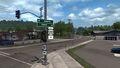
Newport
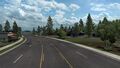
Bend
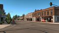
Burns


See also
| Cities | Astoria (Warrenton) • Bend (Terrebonne) • Burns • Coos Bay (North Bend) • Eugene (Springfield) • Klamath Falls • Lakeview • Medford • Newport (Toledo) • Ontario • Pendleton (Rieth) • Portland (Troutdale) • Salem • The Dalles |
|---|---|
| Highways | Interstate 5 • Interstate 82 • Interstate 84 • Interstate 105 • Interstate 205 • Interstate 405 • US 20 • US 26 • US 30 • US 95 • US 97 • US 101 • US 197 • US 199 • US 395 • OR 7 • OR 22 • OR 39 • OR 58 • OR 62 • OR 78 • OR 99 • OR 126 • OR 140 • OR 201 • OR 213 • OR 569 |
| See also | |
| Cities | Boise (Eagle, Meridian) • Coeur d'Alene (Fernan Lake Village) • Grangeville • Idaho Falls • Ketchum (Sun Valley) • Lewiston • Nampa • Pocatello (Inkom) • Salmon • Sandpoint (Ponderay) • Twin Falls |
|---|---|
| Highways | |
| See also | |
| Cities | Casper (Brookhurst, Mills) • Cheyenne (Fox Farm-College, South Greeley) • Cody • Evanston • Gillette • Jackson • Laramie • Rawlins (Sinclair) • Riverton • Rock Springs • Sheridan |
|---|---|
| Highways | Interstate 25 • Interstate 80 • Interstate 90 • Interstate 180 • US 14 • US 14 Alternate • US 16 • US 18 • US 20 • US 26 • US 30 • US 85 • US 87 • US 89 • US 189 • US 191 • US 287 • US 310 • WYO 22 • WYO 28 • WYO 50 • WYO 51 • WYO 59 • WYO 76 • WYO 89 • WYO 94 • WYO 110 • WYO 120 • WYO 135 • WYO 150 • WYO 210 • WYO 212 • WYO 220 • WYO 222 • WYO 258 • WYO 339 • WYO 351 • WYO 374 • WYO 450 • WYO 487 • WYO 789 |
| See also | List of scenery towns in Wyoming • List of landmarks in Wyoming • List of Truck Stops in Wyoming |