Special routes of US 64
There are a number of special routes of U.S. Route 64 (US 64) that connects US 64 to downtown areas, bypass city centers, or provide alternate routes around an area.
US 64 features two different sections of special routes (all business routes) in American Truck Simulator. They are located in the cities of Farmington and Enid respectively.
Business routes
Farmington business route
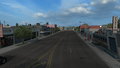
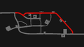
U.S. Route 64 Business (US 64 Bus.) serves downtown Farmington in northwestern New Mexico. It begins along Broadway, then turns onto Main Street for the remainder of its route. In the eastern part of the city, the route also crosses the San Juan River, nearby a service shop.
In real life, US 64 Bus. spans a total length of 3.1 miles (5 km), which is nearly exact to as the featured section in ATS.
Junction list
| mi | km | Destinations | Facilities | Notes |
|---|---|---|---|---|
| 0 | 0 | Western terminus | ||
| 0 | 0 | West Broadway | TOTSO | |
| 0 | 1 | NAF Gas Station | ||
| 0 | 1 | Lake Street | ||
| 1 | 2 | Miller Avenue | ||
| 1 | 3 | Pinon Street | Access to Farmington Plaster & Sons garage | |
| 2 | 3 | Gallon Oil Gas Station / Rest Area | ||
| 2 | 4 | Service Shop | ||
| 2 | 4 | Farmington Recruitment Agency | ||
| 3 | 5 | Eastern terminus |
Gallery
View
Map


Enid business route
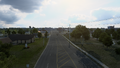
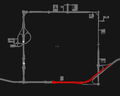
U.S. Route 64 Business (US 64 Bus.) served downtown Enid in northern Oklahoma in American Truck Simulator. In real life, the road has since been decommissioned in 2009; it was established in 1967, replacing the old mainline US 64 through downtown Enid. However, the route is still acknowledged on a highway guide sign east of the junction with US 64 and US 412 in the eastern part of the city[1]; there are no other remaining designations along the former route. The route span a total length of 4.7 miles (7.6 km).
The route in ATS began at an intersection (roughly representing Grand Avenue), serving the downtown district, at US 412. The route overlapped the latter highway via Owen K. Garriot Road as it heads east across the eastern part of the city. The eastern terminus of the route was at an interchange with US 64, which is where the highway is still acknowledge on one guide sign.
Junction list
| mi | km | Destinations | Facilities | Notes |
|---|---|---|---|---|
| 0 | 0 | Downtown District | Western terminus in-game; western terminus of US 412 concurrency; US 64 Bus. continues north inaccessibly | |
| 0 | 0 | Enid Faraday Power Network Service | ||
| 2 | 4 | Eastern terminus; road continues as US 64 and US 412 |
Gallery
View
Map


References
- ↑ US-64, Enid, Oklahoma on Google Street View - September 2023, retrieved October 9, 2023.
See also
| Cities | Alamogordo • Albuquerque • Artesia • Carlsbad • Clovis • Farmington • Gallup • Hobbs • Las Cruces • Raton • Roswell • Santa Fe • Socorro • Tucumcari |
|---|---|
| Highways | |
| See also | |
| Cities | |
|---|---|
| Highways | Interstate 35 • Interstate 40 • Interstate 44 • Interstate 235 • Interstate 244 • US 54 • US 56 • US 59 • US 60 • US 62 • US 64 • US 69 • US 70 • US 75 • US 77 • US 81 • US 83 • US 183 • US 259 • US 270 • US 271 • US 277 • US 281 • US 287 • US 377 • US 385 • US 412 • SH-1 • SH-3 • SH-7 • SH-8 • SH-9 • SH-15 • SH-31 • SH-34 • SH-66 • SH-99 • SH-136 • SH-142 • SH-259A • SH-375 |
| See also | List of scenery towns in Oklahoma • List of landmarks in Oklahoma - List of Truck Stops in Oklahoma |