Notable for its simple structure, the country is bordered by Poland to the north, Ukraine to the east, Hungary to the south, Austria to the west, and the Czech Republic to the northwest. Until the beginning of 1993, the country was united with the Czech Republic as Czechoslovakia.
“
Slovakia is famous for its car manufacturing. The country covers an area of 49,000 square km. It has 38,085 km of paved roads, including 419 km of highways. The most popular destinations are the capital of Bratislava and the High Tatras, the highest Slovakian mountains.
”
~ Official Euro Truck Simulator 2 Website
Cities
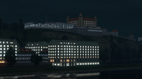
The capital, Bratislava, is the only accessible city in the Euro Truck Simulator 2 base game. Two more cities are introduced in the Going East! DLC.
There are in total three Diaľnica and one Rýchlostná cesta featured in Euro Truck Simulator 2. In older versions, the game would only display Czech versions of road icons in Slovakia, both on the world map and on in-game signage. This has gradually changed such that all icons on the world map now use their proper Slovakian versions, although signage in-game is still fairly inconsistent about whether the Slovak or Czech version is used.
Below motorways, Slovakia designates minor roads as Class I. roads (Slovak: cesta I. triedy). There are currently eight Class I. roads marked on the in-game map, all of which were introduced in the Going East! expansion. Like with their higher-level counterparts (the Diaľnica and Rýchlostná cesta), ETS2 uses Slovakian icons to mark roads on the world map, but uses Czech icons for the in-game signage, although almost no signage currently exists in the game which depicts the I-road classification.
In addition, there are game files for the I/20, but it is currently unused, as neither the world map or in-game signage mark the I/20. This is because the I/20's potential route is already occupied by the D1, running between Košice and the junction with I/21.
In-game, six Class-A and two Class-B Euroroutes (Slovak: Európska cesta) enter and/or pass through Slovakia.