A4 (France)
| Euro Truck Simulator | Euro Truck Simulator 2 | |||||
| Note: This page contains only information about A4 (France) in Euro Truck Simulator 2! | ||||||
The Autoroute ![]() is a highway in France running between Paris and Strasbourg. It's featured in Euro Truck Simulator 2 since the base game, and is one of the few French Autoroutes rendered (almost) in its entirety in the very beginning.
is a highway in France running between Paris and Strasbourg. It's featured in Euro Truck Simulator 2 since the base game, and is one of the few French Autoroutes rendered (almost) in its entirety in the very beginning.
The information of this article is accurate as of version 1.37.
History
The following table describes the rendering history of ![]() in Euro Truck Simulator 2.
in Euro Truck Simulator 2.
| Version | Details |
|---|---|
| Initial release of ETS 2 | The |
| Version 1.26 | The rebuild of Paris area makes the western terminus of Also, service area along the way are signed with names reflecting their real-life counterparts, and the road layout near Strasbourg is also updated to reflect real-life more accurately. |
| Version 1.37 | The road layout around Reims is updated to reflect real-life more accurately. |
Route Details
| Autoroute A4 | ||||
| ↓km↓ | ↑km↑ | Feature | Destinations / Notes | |
|---|---|---|---|---|
| 0 | 433 | Western terminus | ||
| Boulevard Périphérique - towards Paris (Porte de Bagnolet) and | ||||
| 2 | 432 | Tunnel west portal | ||
| 4 | 430 | West-facing on-off ramp (inaccessible to truckers) | ||
| 6 | 426 | Tunnel east portal | ||
| 15 | 407 |
| ||
| 40 | 387 | Entrance / exit of Paris - Reims toll zone | ||
| 56 | 370 | Bridge over railway | ||
| 76 | 350 | Aire de Tardenois (Sud for eastbound; Nord for westbound) | ||
| 90 | 337 | Entrance / exit of Paris - Reims toll zone | ||
| 105 | 319 | |||
| 127 | 304 | Reims | ||
| ||||
| 141 | 283 |
Minor road towards Liège or Dijon
| ||
| 157 | 271 | Entrance / exit of Reims - Metz toll zone | ||
| 182 | 246 |
| ||
| Road works on this section, a short speed reduction to 50 km/h (31 mph) eastbound | ||||
| 233 | 195 | Entrance / exit of Reims - Metz toll zone | ||
| 248 | 180 | Metz (western access, TREE-ET) | ||
| Road works on this section, a short speed reduction to 80 km/h (50 mph) both directions | ||||
| 289 | 132 |
| ||
| 323 | 105 | Entrance / exit of Metz - Strasbourg toll zone | ||
| 342 | 84 | |||
| 389 | 39 |
| ||
| 403 | 25 | Entrance / exit of Metz - Strasbourg toll zone | ||
| 433 | 0 | Eastern terminus | ||
| ||||
Toll
While the ![]() is tolled like other French Autoroutes, its toll zones are independent and involves almost no other roads. As such, a simple toll fee list is available.
is tolled like other French Autoroutes, its toll zones are independent and involves almost no other roads. As such, a simple toll fee list is available.
| Section | Toll |
|---|---|
| Paris – Reims | € 32 |
| Reims – Metz | € 44 |
| Metz – Strasbourg | € 34 |
| Metz – minor road | (TBC) |
| Minor road – Strasbourg | (TBC) |
Gallery
In-game map of Paris before version 1.26. The road to the east (right hand side) was the pre-update A4
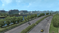
Near western terminus, next to river Seine
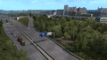
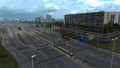
Near Reims
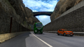
Near the canyon between Metz and Strasbourg
Eastern terminus outside Strasbourg


Trivia
- The section of
 west of the
  junction is still part of
  , but truckers wishing to follow the Euroroute to the west would find it quicker to turn off to instead.
 - The rendered section near Reims is actually Autoroute A344, while the real-life bypasses the city to the south. Nevertheless, most real-life signs on this section of road display . Likewise, the game's rendering makes no attempt to sign the road near Reims separately.
- The cutting rendered in the game between Metz and Strasbourg is different from its real-life counterpart, in that the real-life feature is on a curve convex towards the north, but the rendered cutting is convex towards the west, which means not only the cutting (and the bridge over it) is turned 90 degrees, but the highway also curves in the "wrong" direction inside the cutting.
See Also
- Real-life information of Autoroute A4
 France
Cities ETS1 ETS2 Vive la France! Ajaccio • Bastia • Bayonne • Bonifacio • Bordeaux • Bourges • Brest • Calvi • Civaux • Clermont-Ferrand • Golfech • La Rochelle • Lacq • Le Havre • Le Mans • L'Île-Rousse • Limoges • Marseille (La Mède) • Montpellier • Nantes • Nice • Paluel • Porto-Vecchio • Rennes • Roscoff • Saint-Alban-du-Rhône • Saint-Laurent • Toulouse (Blagnac)Autoroutes Routes nationales Routes territoriales See also List of villages in France • List of landmarks in France • List of Truck Stops in France • Rocade de Bordeaux • Périphérique de Paris • Rocade de Rennes • Périphérique de Toulouse